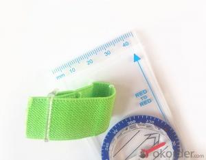

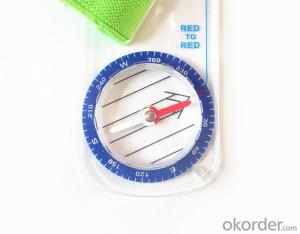
Professional Map Mini-Compass DC35F for Surveying
- Ref Price:
-

- Loading Port:
- Tianjin
- Payment Terms:
- TT OR LC
- Min Order Qty:
- 20 pc
- Supply Capability:
- 10000 pc/month
OKorder Service Pledge
OKorder Financial Service
You Might Also Like


Model: DC35F
Name: Professional map compass, ruler compass
Product Origin: China
Supply Ability: 10,000 pcs/month
Minimum Order: 20 pcs
MOQ for OEM package: 500pcs
Product Size: 128*60*16 (mm)
Features of DC35F
1, professional usage: orientation, distance measuring, measuring slope, azimuth and pitching Angle measurement, drawing, a magnifying glass
2, high quality compass with neck rope, portable and rugged
3, ACRYLIC material, about 2mm thick
4, Damping Dial: to keep the stability of the pointer, more suitable for outdoor environment.
5, Accuracy: accurate and clear, there were 360 degrees azimuth Angle, outer ring is 64-00 system, Liquid filled in the compass for reliable readings.
6, Magnifier function
5,ruler compass,
6,for map measure and drawing
7,one meter neck rope,
8,Liquid filled in the compass for reliable readings,
9, magnifier function.
- Q:I would like to ask the GPS handset and GPS receiver (Surveying and mapping qualification application needs) is there a difference? If yes, what is the difference?
- 1. GPS is a geodetic instrument, with an accuracy of CM, generally for the millimeter,,Divided into (1) pure static type, such as the South Star of the North Star, the accuracy of mm, now the basic domestic,,(2) RTK, RTK can do is use, carrier phase measurement, the precision is cm level, RTK mobile station must have the control hand book, like television and remote similar, but now there are a lot of hand book can be used as handset2. The handset is generally rough field positioning equipment, navigation for mobile phone use, the general size, precision grade m, now can to about 20cm, and can be used for RTK mobile station use (need to access the base station) can reach cm level.Surveying and mapping qualification applications require geodetic measurement equipment, that is, 1.Now domestic GPS, such as the Haida, the south, China, etc. can be measured, not expensive
- Q:Handheld GPS buried in the soil there is a signal
- It depends on how deep you buried the darker the GPS signal, and must ensure that the GPS antenna upward, the above can not be covered with metal objects
- Q:How to set the handheld GPS related parameters and coordinate conversion parameters throughout the country
- Collect the application area of high grade control data in GPS receiver applied earth area (such as a county) find three (or more) uniform grade (accuracy better) or GPS "B" network, the best point is around without interference of electromagnetic wave, vision, the satellite signal is strong. To the local surveying and mapping management department (such as: the local bureau of Surveying and mapping, surveying and Mapping Institute) Gauss plane coordinate copy these points of the Beijing 54 Coordinate System (x, y), the elevation of H and WGS-84 coordinates of the geodetic coordinates (B, L), the high H.
- Q:What is the difference between the phone's GPS and professional handheld GPS features and differences?
- If you travel enthusiasts so you still recommend buying the handheld bar dry batteries can be replaced immediately if it is built in deep mountains and forests where you go oh for charging software installation, you can go to the forum to see the relevant system is very simple and the most important point is that basically all the navigation software has cracked the free version allows you to use it here and I hope to help you
- Q:How do I still stay in the GPS navigation, GPS monitoring of the primary idea? FiveBusiness services, thank you!Future business services
- 6 people travel and adventure7 personal communication terminal (with mobile phones, PDA, electronic map integration)8 time synchronization of electric power, post and telecommunication9 accurate timing of admission10 accurate frequency of admission
- Q:Verify the accuracy of the GPS device to buy back, the way is to use Android under the'gps state 'software, to test the accuracy of real-time single point positioning.1 with two sets of the same Android Tablet Computer (custom machine, type of bad) in the same position for receiving, find that the accuracy is the same (software, are 1-2 meters), but the position would be poor 10 meters or more. It's in the same place.The 2 one is the Android tablet computer, a mobile phone is HTC G10, also received together in the same position, find that the accuracy is not the same as (the latter 20 meters or so), but also may be about 10 meters position difference.The accuracy of this GPS device can reach 1-2 meters, while the same location in real-time single point positioning error of 10 meters, a reasonable explanation.
- 10 meters.To the world in 2013 a total of four global satellite navigation system, in addition to the United States has been in the mature GPS system and commercial operation, the Beidou system, China the European Galileo system, the Russian GLONASS system are still under construction. "The Galileo satellite navigation project" was first conceived by the 30 satellite GPS network to compete with the United States, the beginning of the design proposed in 2008 formally put into operation, and later postponed to 2014, the entire system is only 4 satellites in orbit (as of 2012), in fact it is mainly used to further verify the relevant design and the working system of the system design, after the official start of Galileo satellite will launch. Formal networking satellites are being prepared. China satellite navigation system management office senior engineer Yang Qiangwen introduction, to 2012, the "system" in orbit satellites are also only verify satellite.
- Q:Handheld GPS charge is not into electricity what is the reason
- Reason analysis:1, battery damage. 2, system failure. 3, charger reasons or bad contact.
- Q:Handheld GPS need to put the phone card?
- Travel GPS professional solutions:Put card. Will be equipped with a card at the time of purchase.
- Q:Jia Ming etre20 handheld GPS good
- Jia Ming eTrex 20 has a microSD card slot and 1.7GB built-in memory space eTrex 20 allows you to store more user acquisition information, in addition to the map expansion slot, you can load the map of the global area of Garmin.
- Q:Handheld GPS locator measuring accuracy is about how many meters?
- The handheld machine precision is generally divided into: centimeter decimeter level, 1 meters, 2 meters, 3 meters, 5 meters; the precision is higher, the higher the price. You can consult the Haida official website "mobile MGIS mall".
1. Manufacturer Overview |
|
|---|---|
| Location | |
| Year Established | |
| Annual Output Value | |
| Main Markets | |
| Company Certifications | |
2. Manufacturer Certificates |
|
|---|---|
| a) Certification Name | |
| Range | |
| Reference | |
| Validity Period | |
3. Manufacturer Capability |
|
|---|---|
| a)Trade Capacity | |
| Nearest Port | |
| Export Percentage | |
| No.of Employees in Trade Department | |
| Language Spoken: | |
| b)Factory Information | |
| Factory Size: | |
| No. of Production Lines | |
| Contract Manufacturing | |
| Product Price Range | |
Send your message to us
Professional Map Mini-Compass DC35F for Surveying
- Ref Price:
-
- Loading Port:
- Tianjin
- Payment Terms:
- TT OR LC
- Min Order Qty:
- 20 pc
- Supply Capability:
- 10000 pc/month
OKorder Service Pledge
OKorder Financial Service
Similar products


New products


Hot products


