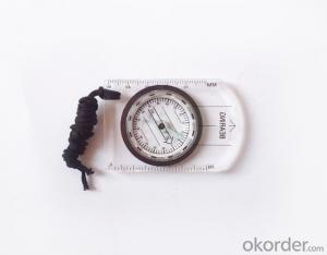
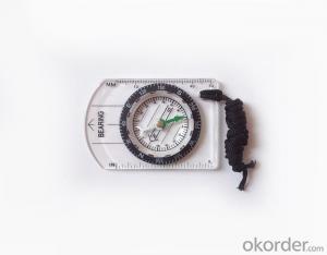
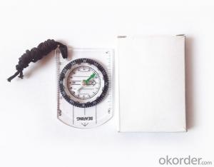
Plastic Map or Ruler CompassDC35 for Surveying
- Ref Price:
-

- Loading Port:
- Tianjin
- Payment Terms:
- TT OR LC
- Min Order Qty:
- 20 pc
- Supply Capability:
- 10000 pc/month
OKorder Service Pledge
OKorder Financial Service
You Might Also Like


Model: DC35-1B
Name: Professional map compass, ruler compass
Product Origin: China
Supply Ability: 10,000 pcs/month
Minimum Order: 50 pcs
MOQ for OEM package: 500pcs
Product Size: 70*48*9 (mm)
Features of DC35-B
1, professional usage: orientation, distance measuring, measuring slope, azimuth and pitching Angle measurement, drawing, a magnifying glass
2, high quality compass with neck rope, portable and rugged
3, ACRYLIC material, about 2mm thick
4, Damping Dial: to keep the stability of the pointer, more suitable for outdoor environment.
5, Accuracy: accurate and clear, there were 360 degrees azimuth Angle, outer ring is 64-00 system, Liquid filled in the compass for reliable readings.
6, Magnifier function
5,ruler compass,
6,for map measure and drawing
7,one meter neck rope,
8,Liquid filled in the compass for reliable readings,
9, magnifier function.
- Q:Handheld GPS brand rankings
- Set of SIBAO products awarded the Beijing independent innovation product identification certificate, satellite navigation and Engineering Excellence Award and other professional awards. At the time, location, navigation and other comprehensive applications, Unistrong successful implementation of hundreds of large projects, services in many national key projects, won the national honor.
- Q:Handheld GPS buried in the soil there is a signal
- It depends on how deep you buried the darker the GPS signal, and must ensure that the GPS antenna upward, the above can not be covered with metal objects
- Q:Ask how to select a google satellite map into a handheld Area GPS
- If an ordinary mobile phone GPS, can install Orville interactive map support pre download any regional satellite map, support for offline use.
- Q:What is the difference between the phone's GPS and professional handheld GPS features and differences?
- If you travel enthusiasts so you still recommend buying the handheld bar dry batteries can be replaced immediately if it is built in deep mountains and forests where you go oh for charging software installation, you can go to the forum to see the relevant system is very simple and the most important point is that basically all the navigation software has cracked the free version allows you to use it here and I hope to help you
- Q:GPS Mu meter which brand is good, handheld high-precision land area measuring instrument
- A German born mu can also recommend a good precision measuring instrument.Simple operation, the screen is large, a few buttonsBoot, and then look at the star almost, to find a field, start and then click on the end of a circle, out of the number ofElectricity can alsoPrecision mody... With a special RTK or not, but what is sure to measure a circleFlat measurement of quasi accurate, biased on what is almost, it can be accepted
- Q:I bought the way k20s, this handheld GPS how
- Choi way handheld GPS feel that you can also be in the last year, the Zhengzhou Bureau of Surveying and mapping seems to be called the wide Han instrument that home to buy, so there is no problem with it, the price is not expensive.
- Q:Professional handheld GPS GARMIN (DR) how to use
- Handheld GPS purposes, the measurement of soil area, linear navigation, auxiliary fishing waypoint navigation point information, traffic data display, such as the use of functional machines should be used manual
- Q:Handheld GPS and mobile phone GPS what is the difference?
- Different: antenna size, function, accuracy, protection level, and has been different in the application layer (handheld GPS support GPS compass navigation and map navigation and other more professional GPS applications);
- Q:Jia Ming etre20 handheld GPS good
- Jia Ming ETREX20 compact portable, solid and rigorous work design, precise positioning, functional improvement, for out of work, travel friends can be used as a reference.
- Q:Fuxin coordinates with the mapping of the seven parameters are what ah there is no professional knowledge to tell my brother I need to fill the gps... Thanks.
- Three translation parameters Delta X, Delta Y, Delta Z, three rotation parameter w X, Omega Y, Omega Z and a zoom M, these parameters need to be calculated in a fixed point under different ellipsoid!
1. Manufacturer Overview |
|
|---|---|
| Location | |
| Year Established | |
| Annual Output Value | |
| Main Markets | |
| Company Certifications | |
2. Manufacturer Certificates |
|
|---|---|
| a) Certification Name | |
| Range | |
| Reference | |
| Validity Period | |
3. Manufacturer Capability |
|
|---|---|
| a)Trade Capacity | |
| Nearest Port | |
| Export Percentage | |
| No.of Employees in Trade Department | |
| Language Spoken: | |
| b)Factory Information | |
| Factory Size: | |
| No. of Production Lines | |
| Contract Manufacturing | |
| Product Price Range | |
Send your message to us
Plastic Map or Ruler CompassDC35 for Surveying
- Ref Price:
-
- Loading Port:
- Tianjin
- Payment Terms:
- TT OR LC
- Min Order Qty:
- 20 pc
- Supply Capability:
- 10000 pc/month
OKorder Service Pledge
OKorder Financial Service
Similar products


New products


Hot products


