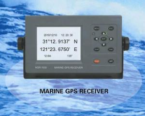


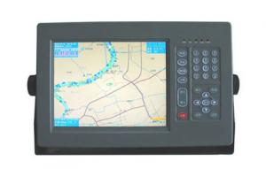
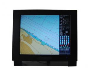
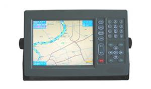
Marine GPS Receiver 5.7 inch LCD
- Ref Price:
-

- Loading Port:
- China Main Port
- Payment Terms:
- TT or LC
- Min Order Qty:
- 10 Set/Sets set
- Supply Capability:
- 1000 Set/Sets Per Year set/month
OKorder Service Pledge
OKorder Financial Service
You Might Also Like


Features of Marine GPS Receiver 5.7 inch LCD
-Designed for marine use, fully complying with the international regulations, IMO MSC
112(73), IEC 61108-1, etc.
-Easy operation with graphic mode display and function keys.
-Has totally 4 ports to output GPS data, which can be respectively configurated for
baudrate and combinationof sentences.
-CCStype approval.
Specifications of Marine GPS Receiver 5.7 inch LCD
|
GPS |
|
|
Receiver: |
12 discrete channels all-in-view, C/A code |
|
RX frequency: |
L1 (1575.42 MHz) |
|
Time to First Fix: |
12 Second (Warm start) |
|
Tracking Velocity: |
900 kt |
|
Update Rate: |
1 second |
|
Accuracy |
|
|
- GPS: |
10 m (95%) |
|
- SOG: |
± 0.2 kt (SOG ≤10 kt) |
|
- COG: |
± 3° (SOG=1-17kt), ± 1° (SOG> 17kt) |
|
LCD |
5.7” silver bright LCD with LED backlight |
|
Interface |
|
|
Output: |
GBS, GLL (L/L), VTG , ZDA, WPL, etc. |
|
Input: |
HDT, VBW , etc. |
|
Electrical Interfaces: |
RS-422 (4 outputs, 1 input) |
|
Power Supply |
DC24V(10V~38V) |
|
Size |
145(H)x264(W) x80(D)mm |
|
Weight |
abt 0.4kg |
Certifacates for Marine GPS Receiver 5.7 inch LCD

Our Mission for Marine GPS Receiver 5.7 inch LCD

Factory of Marine GPS Receiver 5.7 inch LCD

Shipment for Marine GPS Receiver 5.7 inch LCD

- Q:Is there any navigation aid in the era of OL? Download address!
- With the plugin not too high, backfire, repent and be saved.
- Q:How about GPS navigation, okay?
- GPS industry Lijiaming is the best quality, their products are divided into series, GPS handheld game player for outdoor climbing, explorers go wild life insurance with and coordinate with industry gathering.
- Q:I was playing in the era of OL navigation with the wizard button in how to set a more accurate route. Do not use sacred navigation, I would like to use a pure key simulation, there is no call memory, set, I hope the master to help me think of ideas, grateful
- The interpretation of LX is very good, very accurate, I've tried to catch the point color, position, keyboard control, sand table, basically all over. The basic solution, I don't have it now, I use the lazy God navigation, do not engage in their own, but also cheap 10 dollars a month, to support naval skills correction, automatic cruise, I wonder what they did, I probably simulated, or failure, so it is here that.
- Q:What navigation instrument was used by Zheng He in the voyages of the West
- Ian, large Ian,Use the chart to locate and Ian navigation
- Q:Application of satellite positioning system
- 11 geodetic measurements of various levels12 road and various line lofting13 underwater topographic survey14 crustal deformation measurement, dam and large building deformation monitoring15.GIS application16 construction machinery (tyre crane, bulldozer, etc.) control17 the application of precision agriculture GPS in road engineering is mainly used for the establishment of a variety of road engineering control network and the determination of external control points, etc.. With the rapid development of highway, puts forward higher requirements for the survey, due to the long lines of known points less, therefore, measured by conventional means of distribution network not only difficult, but it is difficult to meet the requirements of high precision. In the country has adopted GPS technology to establish high-precision control network line head, and then use conventional methods laid wire encryption. Practice has proved that the error in the tens of kilometers within the range of only about 2 cm, to achieve the accuracy of the conventional method is difficult to achieve, but also greatly ahead of schedule. GPS technology is also applied to the control of large bridge. Because no visibility, can constitute a strong network, improve the precision of points, but also very effective fulcrum for testing conventional measurement. GPS technology is also widely used in tunnel measurement, GPS measurement no visibility, reduce intermediate links, so the conventional method, high speed and high precision, which has obvious economic and social benefits.
- Q:Who can give a world map of the great navigation era OL
- Give you an e-mail address to send a GPS software, he has spent half a year. security
- Q:It's like the captain's studioSome M me
- I've been playing for a long time!I never met!
- Q:Ancient navigation depends on navigation
- According to the "Zheng He Zheng He" charts, using hydrographic needle (24/48 azimuth compass navigation) with Ocean Star drawing operation (celestial navigation), at that time is the most advanced navigation technology. Zheng He's fleet, the day with the compass navigation, night watch stars and method is used to keep water compass heading.
- Q:High frequency. SSB radio. Satellite navigationI want to study marine electronic equipment, a variety of marine radar. High frequency. Single sideband radio. Satellite navigation. All the fish finder. Sounder maintenance and so on which can enlighten me, where is the training school, I graduated for several years, I want to learn the craft.
- A marine radar is enough for your study, you can consult the Xiamen Marine College Jimei University, where many teachers navigation equipment maintenance, if you are born in the navigation technology specialty, the better, directly in your school can learn.
- Q:How to use navigation
- Assistant: navigation assistant - the game started by Home- - their own settings can also be used
1. Manufacturer Overview |
|
|---|---|
| Location | Jiangsu,China |
| Year Established | 2008 |
| Annual Output Value | US$1 Million - US$2.5 Million |
| Main Markets | Mid East;Eastern Europe;South America |
| Company Certifications | |
2. Manufacturer Certificates |
|
|---|---|
| a) Certification Name | |
| Range | |
| Reference | |
| Validity Period | |
3. Manufacturer Capability |
|
|---|---|
| a)Trade Capacity | |
| Nearest Port | Shanghai |
| Export Percentage | 81% - 90% |
| No.of Employees in Trade Department | 150 |
| Language Spoken: | English, Chinese |
| b)Factory Information | |
| Factory Size: | Above 20,000 square meters |
| No. of Production Lines | 20 |
| Contract Manufacturing | OEM Service Offered;Design Service Offered |
| Product Price Range | Average |
Send your message to us
Marine GPS Receiver 5.7 inch LCD
- Ref Price:
-
- Loading Port:
- China Main Port
- Payment Terms:
- TT or LC
- Min Order Qty:
- 10 Set/Sets set
- Supply Capability:
- 1000 Set/Sets Per Year set/month
OKorder Service Pledge
OKorder Financial Service
Similar products
New products


Hot products
Related keywords

