
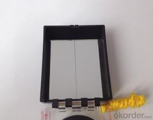
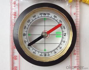
Map Scale Compass DC45-6A
- Ref Price:
-

- Loading Port:
- China Main Port
- Payment Terms:
- TT OR LC
- Min Order Qty:
- -
- Supply Capability:
- -
OKorder Service Pledge
OKorder Financial Service
You Might Also Like


Features
1, professional usage: orientation, distance measuring, measuring slope, azimuth and pitching Angle measurement, drawing, a magnifying glass
2, high quality compass with neck rope, portable and rugged
3, ACRYLIC material, about 2mm thick
4, Damping Dial: to keep the stability of the pointer, more suitable for outdoor
environment.
5, Accuracy: accurate and clear, there were 360 degrees azimuth Angle, outer ring is 64-00 system, Liquid filled in the compass for reliable readings.
Model: DC45-6A
Name: Professional map compass, ruler compass
Product Origin: China
Supply Ability: 10,000 pcs/month
Minimum Order: 50 pcs
MOQ for OEM package: 500pcs
Product Size: 122*64*22 (mm)
Payment term: TT/ LC
- Q:What is the difference between industrial GPS handset and mobile navigation
- 3, professional handheld machine with industrial design. First of all, if used outdoors, then fell, and so on are likely to water, and this thing is also very expensive, so the opportunity to have a high professional anti shock waterproof performance.4, different screen design. If you look carefully, you can see in the outdoor light, mobile phone can not see the contents of the screen, while the professional handset is not the same, can see clearly in bright light, does not affect the work of foreign trade operations.
- Q:Handheld GPS navigation is what? Where to buy handheld GPS navigation, how to select GPS navigation?
- Select the main consideration of the following issues on the line:1, GPS receiving capacity, in the interior, the streets can be measured on a few stars, while looking at the speed of the search star? If a place for 2 - 3 minutes accurate positioning can be used2, the map is the latest, often used to check those routes3, battery life is how long to ask4, accessories, such as support, car charge, the size of the memory card should be clearly presentedThe location of the purchase is usually in the car decoration department or the electronic mall or digital products store salesAffordable mall can look at the old brand, operating for many years, where I bought the electronic dog
- Q:Is it accurate to measure highway mileage with GPS handheld
- As long as you can receive more than four satellites, and the signal is good, the accuracy should be high.
- Q:How about the accuracy of the GPS handset?
- So the selection depends on your needs the function and budget. Haida official website mall "mobile MGIS mall".
- Q:Hand held GPS coordinate conversion method
- Three parameter test DX, DY, DZ, DA, DF after the conversion parameters of the five, must be prompted to enter the handheld GPS, while the input area of the central meridian longitude. E on behalf of the east longitude, projection ratio of 1, the deviation of things to the north and south of the deviation of 0, and set the unit for M. Enter these parameters, should be taken to the field test, check whether these five parameters are correct. The method is selected, vision, GPS receiving signal strength of the feature points in the field (such as linear object intersections, independent features, etc.) is the best stone control points were measured and compared with theory and find out the coordinates of these points. If the results of the comparison exceed the nominal accuracy of the instrument, the conversion parameters or the problems that should be found should be recalculated.
- Q:Highway measurement with GPS I do not know which of the base station settings and mobile station settings I are very vague, to the instrument to build a coordinate system how to build the relevant issues to me
- Defects of conventional measurement methods:1, the specification of the length of the attached wire, the length of the wire and the length of the wire between the nodes have strict requirements, generally for high grade roads are required to meet the requirements of the first line. In this way, the length of the wire shall not be more than 10 km, or the length of the wire shall not exceed the length of the wire attached to the attachment of the wire length of 0.7 times. This requirement is generally difficult to achieve in the actual work, often appear super standardized operations.2, to collect the starting point for the general route of measurement and control is difficult to ensure the same measurement system, the measurement and measurement, often in the city of control points mixed together, the compatibility between systems, if the starting point is not compatible, is bound to affect the quality of measurement.3, serious damage to the national site, the impact of measurement operations. Due to the country's basic control points, mostly completed in 50s and 60s, after more than 30 years, some point due to the needs of economic construction is destroyed, and some people because of the lack of knowledge of human destruction. Route survey work in these areas, often in the 50 km above all can not find the wire control points. The quality of the route control survey is not guaranteed.4, ground visibility difficulties often affect the implementation of conventional measurement. The control points of the general route shall be located within 300 meters from the course. Due to visibility reasons, it is difficult to meet the conditions, even in a large range, and the dense shrub forest area, simply can not implement conventional control measure.
- Q:Magellan GPS handheld why so many people choose not to say that the map is not good
- Outdoor use three times a year also on the trip, but also want to use both sides can be used to the best, so these are the best of the two Ming and Magellan did not know that the election of the good, but I am willing to build businesses with the best Ming of the 450.Chasing the answerIf only in the city with less than 610510 can be upgraded Magellan navigation, 610 more than and 510 three axis electronic compass if you don't like the original forest does not receive any signal where there is no whatTake a look at yourself
- Q:The navigation module it is "selph" three generation? Another one I mainly use it to measure the land area, easy to use, the error is not big?I want to buy Magellan 500 do not know whether it is good to use
- A type specific.GPS chip area measurement is the most "selph" 3 generation, special machine is very good, the error is very small.
- Q:What qualifications should a normal GPS locator have?
- Patent, business licenseLook what kind of
- Q:Handheld GPS locator measuring accuracy is about how many meters?
- The higher the accuracy, the higher the price. You can consult the Haida official website mobile MGIS mall
1. Manufacturer Overview |
|
|---|---|
| Location | |
| Year Established | |
| Annual Output Value | |
| Main Markets | |
| Company Certifications | |
2. Manufacturer Certificates |
|
|---|---|
| a) Certification Name | |
| Range | |
| Reference | |
| Validity Period | |
3. Manufacturer Capability |
|
|---|---|
| a)Trade Capacity | |
| Nearest Port | |
| Export Percentage | |
| No.of Employees in Trade Department | |
| Language Spoken: | |
| b)Factory Information | |
| Factory Size: | |
| No. of Production Lines | |
| Contract Manufacturing | |
| Product Price Range | |
Send your message to us
Map Scale Compass DC45-6A
- Ref Price:
-
- Loading Port:
- China Main Port
- Payment Terms:
- TT OR LC
- Min Order Qty:
- -
- Supply Capability:
- -
OKorder Service Pledge
OKorder Financial Service
Similar products


New products


Hot products


Related keywords

