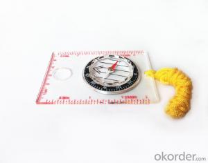


Map Scale Compass DC35-1A
- Ref Price:
-

- Loading Port:
- China Main Port
- Payment Terms:
- TT OR LC
- Min Order Qty:
- -
- Supply Capability:
- -
OKorder Service Pledge
OKorder Financial Service
You Might Also Like


Model: DC35-1A
Name: Professional map compass, ruler compass
Product Origin: China
Supply Ability: 10,000 pcs/month
Minimum Order: 50 pcs
MOQ for OEM package: 500pcs
Product Size: 86*60*10 (mm)
Features
1, professional usage: orientation, distance measuring, measuring slope, azimuth and pitching Angle measurement, drawing, a magnifying glass
2, high quality compass with neck rope, portable and rugged
3, ACRYLIC material, about 2mm thick
4, Damping Dial: to keep the stability of the pointer, more suitable for outdoor
environment.
5, Accuracy: accurate and clear, there were 360 degrees azimuth Angle, outer ring is 64-00 system, Liquid filled in the compass for reliable readings.
6, Magnifier function
- Q:How to set the handheld GPS related parameters and coordinate conversion parameters throughout the country
- Three parameter test DX, DY, DZ, DA, DF after the conversion parameters of the five, must be prompted to enter the handheld GPS, while the input area of the central meridian longitude. E on behalf of the east longitude, projection ratio of 1, the deviation of things to the north and south of the deviation of 0, and set the unit for M. Enter these parameters, should be taken to the field test, check whether these five parameters are correct. The method is selected, vision, GPS receiving signal strength of the feature points in the field (such as linear object intersections, independent features, etc.) is the best stone control points were measured and compared with theory and find out the coordinates of these points. If the results of the comparison exceed the nominal accuracy of the instrument, the conversion parameters or the problems that should be found should be recalculated.
- Q:Is it accurate to measure highway mileage with GPS handheld
- Measuring mileage, since the unit has been upgraded to the inside, it is quite accurate oh
- Q:I am a handheld GPS precision is low, how to use to be able to improve certain accuracy.
- Look at the maximum accuracy of GPSIf the difference accuracy can reach 1cm you can connect CORS single base station and other network RTK way to achieve the corresponding accuracy
- Q:GPS handheld function to measure it?
- Depends on the accuracy of the range you require, if the accuracy of the 3-5 meter can be used for ranging, measuring area, latitude and longitude, elevation information, etc.
- Q:Highway measurement with GPS I do not know which of the base station settings and mobile station settings I are very vague, to the instrument to build a coordinate system how to build the relevant issues to me
- For long tunnels, the conventional measurement of large bridges has the following limitations:1, long tunnels, bridges and other structures generally require the measurement level of four or more. With conventional measurement methods, often adopt the measure to increase the number of methods to extend the observation time, time consumption and labor consumption to try to improve the accuracy of.2, the long tunnel and bridge for the complex terrain region difficult, conventional control measure for visibility and network shape, often cut down the workload is quite large, so the measurement of the cost of a large, hard work.Link control network of high precision 3, long tunnel and bridge and low precision and route network, although with adjustment methods can be overcome, but because of the terrain conditions are difficult, the measurement workload to its connection, and is not too easy. In practical work, the control of the structure and the measurement of the route are often out of touch.
- Q:Handheld GPS, the measurement of arable land, fixed point and circle test, which is more accurate,
- If the area is measured, are almost. However, if the measurement point is only the case, the dynamic GPS is now the general error can be guaranteed within 3cm, the total station can be guaranteed to the millimeter.
- Q:Professional handheld GPS GARMIN (DR) how to use
- Look at the functional machine should use the instructions
- Q:Handheld GPS and mobile phone GPS what is the difference?
- Handheld GPS also supports GPS compass navigation and map navigation as well as other more professional GPS applications; mobile GPS can work with fewer, more consumer grade product applications
- Q:What qualifications should a normal GPS locator have?
- Patent, business licenseLook what kind of
- Q:Handheld GPS locator measuring accuracy is about how many meters?
- The handheld machine precision is generally divided into: centimeter decimeter level, 1 meters, 2 meters, 3 meters, 5 meters;
1. Manufacturer Overview |
|
|---|---|
| Location | |
| Year Established | |
| Annual Output Value | |
| Main Markets | |
| Company Certifications | |
2. Manufacturer Certificates |
|
|---|---|
| a) Certification Name | |
| Range | |
| Reference | |
| Validity Period | |
3. Manufacturer Capability |
|
|---|---|
| a)Trade Capacity | |
| Nearest Port | |
| Export Percentage | |
| No.of Employees in Trade Department | |
| Language Spoken: | |
| b)Factory Information | |
| Factory Size: | |
| No. of Production Lines | |
| Contract Manufacturing | |
| Product Price Range | |
Send your message to us
Map Scale Compass DC35-1A
- Ref Price:
-
- Loading Port:
- China Main Port
- Payment Terms:
- TT OR LC
- Min Order Qty:
- -
- Supply Capability:
- -
OKorder Service Pledge
OKorder Financial Service
Similar products


New products


Hot products


Related keywords

