
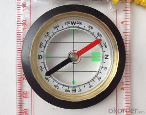
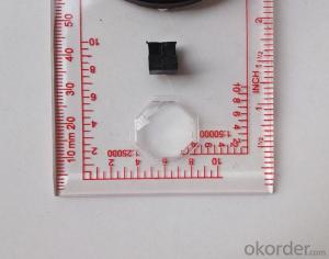
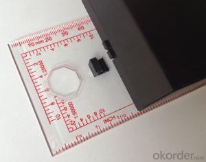


Map compass DC45-6A
- Ref Price:
-

- Loading Port:
- Tianjin
- Payment Terms:
- TT OR LC
- Min Order Qty:
- -
- Supply Capability:
- 5000 pc/month
OKorder Service Pledge
OKorder Financial Service
You Might Also Like


Product details
Model: DC45-6A
Name: Professional map compass, ruler compass
Product Origin: China
Supply Ability: 10,000 pcs/month
Minimum Order: 50 pcs
MOQ for OEM package: 500pcs
Product Size: 122*61*22 (mm)
Color: OEM
Features
1, professional usage: orientation, distance measuring, measuring slope, azimuth and pitching Angle measurement, drawing, a magnifying glass
2, high quality compass with neck rope, portable and rugged
3, ACRYLIC material, about 2mm thick
4, Damping Dial: to keep the stability of the pointer, more suitable for outdoor
environment.
5, Accuracy: accurate and clear, there were 360 degrees azimuth Angle, outer ring is 64-00 system, Liquid filled in the compass for reliable readings.
6, Magnifier function
- Q:Is it accurate to measure highway mileage with GPS handheld
- Can only say that the handheld GPS measurement of highway mileage can be a reference, if you want to measure the accuracy or sub meter level or professional measuring tools better
- Q:I am a handheld GPS precision is low, how to use to be able to improve certain accuracy.
- If the carrier phase measurement function is not available, you have the maximum accuracy of GPS accuracy of 1-10This can only improve the observation environment using SBAS and other ways to improve the accuracy
- Q:Mobile GPS can replace professional handheld GPS
- Ziphah measured Mu instrument, a key measurement area, the use of simple, SV-118, with high precision imported GPS module and antenna, accurate measurement, the block walk in a circle to measure the size and graphics trajectory, 550 yuan, USB charging, large capacity lithium battery, black and white screen to see the clear day for outdoor use.
- Q:What do you need to test for GPS?
- As a high-tech product, GPS has a very complex technical parameters. However, as people's living standards improved rapidly, more and more ordinary people began to pay attention to the positioning and navigation tools originated from the military. Because the convenience it brings is unprecedented. In order to let everyone out of all the technical parameters of GPS receiver, no longer confused at the time of purchase, the author selected six of the most important technical indicators, one by one to explain to you. 1 parallel channels on the market most of the GPS receiver is a 8 channel, 12 channel, the 16 channel, which allows them to continuously track the information of each satellite. Some GPS devices only have 2 to 5 parallel channel receiving satellite signals, because the average of 8 satellites are visible, which means that the GPS receiver must visit each of the satellites in order to obtain information about each satellite. All of our products are in Shenzhen channel 16 channel, multi-channel parallel GPS receiver, including the advantages of rapid cold start and initialization of satellite information, but also in the forest area can have a better reception. General 12 channel receiver does not require an external antenna, unless you are in a bad environment conditions such as closed space, such as the cabin, the car. 2 the sensitivity of the GPS satellite signal to the ground has been very weak, as well as ground wireless communication clutter interference. The lowest traceable signal strength of the GPS receiver determines how much useful signal is received. A GPS receiver with a lower minimum tracking signal strength has a higher sensitivity, and can receive more available satellites under bad conditions
- Q:Handheld GPS positioning, can be directly uploaded to the computer, and the computer has a scalable map to mark the upload point. The above system, now there are 20Such as the title, I want to achieve the final function: through the manual to a point, with a hand-held GPS locator will be recorded in the specific latitude and longitude, and sent to the network in real time, for my computer to mark these points on the map. If you can directly enter the site of some of the information, directly to the above is the bestIf you have the above equipment, please indicate the scientific name, and the specific application industry.Thanks.
- 7 support for added map marking, distance measurement and area measurement, location name display.8 support Hawkeye display thumbnail map, screenshot function.9 support to add custom logo icon, the user can change icon.
- Q:I am a handheld GPS precision is low, how to use to be able to improve certain accuracy
- If you can join the CORS network, the accuracy of decimeter to centimeter level.
- Q:Highway measurement with GPS I do not know which of the base station settings and mobile station settings I are very vague, to the instrument to build a coordinate system how to build the relevant issues to me
- Application of GPS in Highway SurveyHighway routes are generally in a ribbon corridor. It is often used in the plane control measurement, which includes the form of wire, closed wire, wire and so on. For important structures such as bridges, bridges, tunnels, etc., but also arranged into triangular network, linear lock and other forms.
- Q:GPS Mu meter which brand is good, handheld high-precision land area measuring instrument
- Simple operation, the screen is large, a few buttonsBoot, and then look at the star almost, to find a field, start and then click on the end of a circle, out of the number ofElectricity can alsoPrecision mody... With a special RTK or not, but what is sure to measure a circleFlat measurement of quasi accurate, biased on what is almost, it can be accepted
- Q:Jia Ming etre20 handheld GPS good
- Jia Ming eTrex 20 has an enhanced 2.2 inch screen, a color rendering effect of 65 thousand TFT, a readable display in the sun. Durable waterproof, but also upgraded the interface to retain the existing hardness and toughness, to withstand dust, dirt, moisture and water erosion, these are not the legendary navigator opponent.
- Q:Handheld GPS locator measuring accuracy is about how many meters?
- The higher the accuracy, the higher the price. You can consult the Haida official website mobile MGIS mall
1. Manufacturer Overview |
|
|---|---|
| Location | |
| Year Established | |
| Annual Output Value | |
| Main Markets | |
| Company Certifications | |
2. Manufacturer Certificates |
|
|---|---|
| a) Certification Name | |
| Range | |
| Reference | |
| Validity Period | |
3. Manufacturer Capability |
|
|---|---|
| a)Trade Capacity | |
| Nearest Port | |
| Export Percentage | |
| No.of Employees in Trade Department | |
| Language Spoken: | |
| b)Factory Information | |
| Factory Size: | |
| No. of Production Lines | |
| Contract Manufacturing | |
| Product Price Range | |
Send your message to us
Map compass DC45-6A
- Ref Price:
-
- Loading Port:
- Tianjin
- Payment Terms:
- TT OR LC
- Min Order Qty:
- -
- Supply Capability:
- 5000 pc/month
OKorder Service Pledge
OKorder Financial Service
Similar products


New products


Hot products


