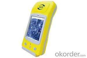
GIS K300
- Ref Price:
-

- Loading Port:
- China Main Port
- Payment Terms:
- TT OR LC
- Min Order Qty:
- -
- Supply Capability:
- -
OKorder Service Pledge
OKorder Financial Service
You Might Also Like


PJK-300
PJK-300 is the most cost-effective dual-frequency network RTK rover. PJK-300 solution includes the new GIS rugged GNSS receiver running Windows Mobile? 6.5 operating system, the comprehensive GIS field software and the new GIS (L1/L2 GNSS) antenna.
Advanced GNSS Solution
PJK-300 – dual-frequency, all-in-view network RTK rover - with the embedded GIS technology delivers a long-range RTK performance, fast-initialization time, and high-precision. For specific survey applications it can provide outstanding real-time centimeter-level accuracy even in handheld configuration.
Designed For Efficient Network RTK
Very lightweight, with compact and rugged design, as well as large memory and autonomy, PJK-300 has been designed for a confortable and productive field use. Its extended wireless communications (Bluetooth, Wi-Fi) and embedded GSM/GPRS modem make PJK-300 a powerful solution suitable for any network RTK applications.
Best Value For A High-End Survey Solution
PJK-300 is extremely cost-effective offering meeting the most demanding requirements for a high-end survey solution. It provides possibility to interwork with a wide range of survey instruments and accessories to run complete survey jobs, including site calibration, stake out, and survey projects where total stations are used.
PJK-300 - Specifications
Product specifications
· Constellation : GPS, GLONASS, SBAS
· Frequency : L1, L2
· Channels : 45
· Update Rate : 0.05 sec
· Data format : RTCM 3.1, ATOM, CMR(+), NMEA
· Raw data output : Yes
· Real-time Accuracy - RTK mode (HRMS) : 1 cm
· Real-time Accuracy - DGPS mode (HRMS) : < 30 cm
· Real-time Accuracy - SBAS mode (HRMS) : < 50 cm
· Post-Processed Accuracy (HRMS) : 0.5 cm + 1 ppm
· Time to first fix : 15 sec
· Initialization range : Up to 40 km
· Processor : 806 MHz
· Operating system : Windows Mobile 6.5
· Communications : GSM/GPRS, BT, WLAN
· Unit size (mm / inches) : 190x90x43mm / 7.5x3.5x1.7in
· Weight : 0.62 kg / 1.43 lb
· Display : 3.5
· Memory : 256 MB SDRAM / 2 GB NAND / SDHC
· Temp Min (°C) : -20°C / -4°F
· Temp MAx (°C) : 60°C / 140°F
· Waterproof : Yes
· Shock & vibration : ETS300 019 & MIL-STD-810
· Power (type - lifetime) : 6600 mAh Li-Ion / > 8 hrs
· Antenna Type : Internal / External
· Firmware options : Yes
· Software options : Yes
- Q:Handheld GPS buried in the soil there is a signal
- It depends on how deep you buried the darker the GPS signal, and must ensure that the GPS antenna upward, the above can not be covered with metal objects
- Q:Saying that we have a project in front of it is to do so, it is surprising that there are wood
- To 3D GPS it is not easy to find the map
- Q:My cell phone: HTC Hero 200Question type: Internet softwareMy work needs to locate, record, output, and input GPS coordinates. Track record measurement, coordinate transformation. So would you have a professional security software under the table, so go out with a mobile phone or a PAD, or N equipment back to survey the tired,
- Taobao to enter the online shopping, mobile phone navigator on the line, I suggest you download the Careland navigation map, or tiger map
- Q:Handheld GPS, the measurement of arable land, fixed point and circle test, which is more accurate,
- If the area is measured, are almost. However, if the measurement point is only the case, the dynamic GPS is now the general error can be guaranteed within 3cm, the total station can be guaranteed to the millimeter.
- Q:GPS Mu meter which brand is good, handheld high-precision land area measuring instrument
- A German born mu can also recommend a good precision measuring instrument.
- Q:Can a handheld navigator connect a cell phone? Thank you
- Now basically use the phoneEasy update and operation
- Q:The navigation module it is "selph" three generation? Another one I mainly use it to measure the land area, easy to use, the error is not big?I want to buy Magellan 500 do not know whether it is good to use
- Professional handheld GPS only Magellan and set SIBAO
- Q:Jia Ming etre20 handheld GPS good
- The new generation of the eTrex series is the first generation of user level receivers that can track both GPS and GLONASS satellites. GLONASS global navigation satellite system developed by Russian Federation, fully put into use. When using the GLONASS satellite, the average time for the receiver to lock the target is about 20% faster than GPS. And, when using both GPS and GLONASS, the receiver has the ability to lock more than 24 satellites as compared to GPS alone.
- Q:I am ready to go to the field to go to college, but I do not know how to buy a handheld GPS, I hope you recommend. The most important thing is easy to carry.
- At present, the formal channels genuine licensed not so cheap, some refurbished machines may have. The cheapest machines now have about 900-1000!
- Q:Handheld GPS locator measuring accuracy is about how many meters?
- The handheld machine precision is generally divided into: centimeter decimeter level, 1 meters, 2 meters, 3 meters, 5 meters;
1. Manufacturer Overview |
|
|---|---|
| Location | |
| Year Established | |
| Annual Output Value | |
| Main Markets | |
| Company Certifications | |
2. Manufacturer Certificates |
|
|---|---|
| a) Certification Name | |
| Range | |
| Reference | |
| Validity Period | |
3. Manufacturer Capability |
|
|---|---|
| a)Trade Capacity | |
| Nearest Port | |
| Export Percentage | |
| No.of Employees in Trade Department | |
| Language Spoken: | |
| b)Factory Information | |
| Factory Size: | |
| No. of Production Lines | |
| Contract Manufacturing | |
| Product Price Range | |
Send your message to us
GIS K300
- Ref Price:
-
- Loading Port:
- China Main Port
- Payment Terms:
- TT OR LC
- Min Order Qty:
- -
- Supply Capability:
- -
OKorder Service Pledge
OKorder Financial Service
Similar products


New products


Hot products


