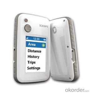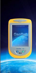
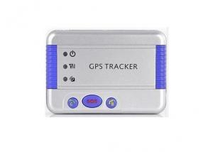
GIS K2
- Ref Price:
-

- Loading Port:
- China Main Port
- Payment Terms:
- TT OR LC
- Min Order Qty:
- -
- Supply Capability:
- -
OKorder Service Pledge
OKorder Financial Service
You Might Also Like
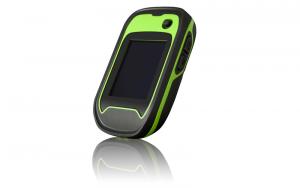


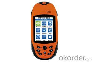
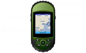
GeoRef K2 series is a high-sensitive GIS data collector specially designed for the industrial professionals. It offers overall GNSS/GIS solutions, which is compatible with the international main-stream GIS platforms especially KQ GIS, while supporting large-size raster image data (up to 10GB) and hundred megabyte level vector data loading. GeoRef K2 series, with independent intellectual property, offers high-accuracy real-time differential and kinematic survey for post-processing. Based on Windows CE operating system, KQ GEO can offer users customized applications or functions according to different requirements. GeoRef K2 series, even mini-size, lightweight but rugged, is suitable for complicated environment.
Advanced System Configuration
◆ Windows CE 6.0 operating system
◆1GHz industrial processor
◆ 256MB/512MB massive storage, 512MB flash memory
◆ 3.5 inches professional sunlight-readable color touch screen
◆ 3.7V, 4200mAh long-life Li-Ion battery, up to 8h continuous working with one battery
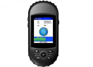
Professional GPS Functions
◆ 50-channels+ L1C/A
◆ Support SBAS (WAAS, EGNOS, MSAS, GAGAN)
◆ Built-in high-sensitive and anti-jamming GPS antenna
Integrated 2G/3G Wireless Communication
◆ Industrial 2G/3G wireless communications modem
◆ Data exchanging between the server center and the mobile GPS terminal
◆ Convenient for task assignment, online monitoring, data uploading, and rapid decision-making
Integrated Bluetooth and WiFi Wireless Communications
◆ Built-in Bluetooth and WiFi wireless communication modem
◆ Stable short distance wireless data transmission
Integrated 3D Electronic Compass
◆ Effective assistance to the GPS fieldwork
◆ High-speed and high-accuracy A/D conversion
◆ Zero pointing correction
Industrial Design
◆ Industrial integrated multi-functions
◆ IP67, waterproof and dustproof, against 1.5m natural falling
◆ For high-standard vehicle navigation GPS
Visual Digital Image
◆Built-in high resolution camera supports on-site image acquisition and annotation
◆ Automatically matching GPS coordinates with image attributes
◆ Built-in microphone supports on-site audio acquisition and annotation
Professional Fieldwork Collection Software
GeoPac is the latest multifunctional GNSS data collection, processing and management software, containing data collection, edition, detection, analysis and storage, which is widely applied in different fields such as engineering survey, road engineering, water conservancy, forestry and etc.
◆ Comprehensive functionalities, meeting both requirements of high-accuracy engineering survey and field data collection.
◆ High-accuracy rapid positioning, meeting different accuracy requirements.
◆ User-friendly interface makes heavy-duty fieldwork easy and convenient.
◆ Universal coordinate systems with the popular Gauss, UTM, Mercator projection, etc.
◆ Various convenient coordinate transformation tools, making plane 4-parameter, spatial 7-parameter and 3-parameter transformation easier.
◆ Multiple professional data collection methods.
◆ Complete attributes library and easy setup make data collection, edition and management super-easy, greatly increasing fieldwork efficiency.
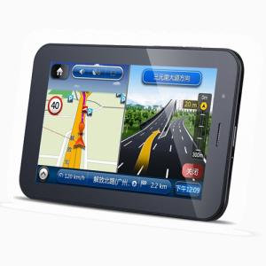
- Q:How to display portable navigator
- However, it is recommended to close to the central console, so that even if the bumpy road is not easy to fall off,
- Q:I booked a Yue car, want to install navigation system, is portable or car type can not make up their mind, which help to give a recommendation, recommend the brand and price, thank you.
- It is best to use the car special car flying rhyme, I am, portable one is the impact of sight, two is the interior is not uniform, some confusion, since the car, what portable ah
- Q:Portable GPS navigation machine, using FM to launch, a squeaky noise sound, but another fm,But instead of changing the FM, listening to the radio, GPS is charging the car, no noise.
- 1 change the frequency, it is best not to be occupied by the radio frequency2 quality problems, exchange it
- Q:If not, then how to update the map?
- It depends where you bought itIf you want to buy in the 4S shop to buy their own updates should be free of charge
- Q:Portable navigation built-in hard disk or a good memory card
- Memory card good. Navigation does not require speed. Hard drive and fear of falling and charging. These are not the memory card, but also cheap.
- Q:What kind of car portable navigator good?
- The main consideration to 1, the speed of the search star; 2, navigation map; 3, navigator after-sales service; 4, navigator chip; 5, screen size and resolution, etc..
- Q:The more detailed the betterI am surprised that no one can answer my question!
- Talk about his navigation performance, it is the speed of operation I have seen faster, more intelligentIn particular, the design of navigation software, very novel, whether the bridge or the next bridge tips!!
- Q:How to upgrade their portable navigation Kay
- The portable CE system is generally WIN, according to your original Careland version number to upgrade, so that it is easy to succeed, otherwise it is very difficult to succeed. To upgrade the main program and map pack". What is your current Careland version?View method:Kelid, "function" - "help" - "version" - "version number", you can see, such as: C1204-C7901-2821J0A, this is the Kelid version number.
- Q:Portable car navigation can be charged with a mobile phone charger
- Can be like a jack.Mobile charger output current and voltage to meet the requirements of the navigator can be charged, the navigator on the back of the general current and voltage requirements.
- Q:Portable navigator function? Portable navigator function?
- 3 National Road Network (refers to map) 4 input Quanpin, searching method of various destination handwriting etc.. 5 high-definition wireless FM launch, (car without this feature)
1. Manufacturer Overview |
|
|---|---|
| Location | |
| Year Established | |
| Annual Output Value | |
| Main Markets | |
| Company Certifications | |
2. Manufacturer Certificates |
|
|---|---|
| a) Certification Name | |
| Range | |
| Reference | |
| Validity Period | |
3. Manufacturer Capability |
|
|---|---|
| a)Trade Capacity | |
| Nearest Port | |
| Export Percentage | |
| No.of Employees in Trade Department | |
| Language Spoken: | |
| b)Factory Information | |
| Factory Size: | |
| No. of Production Lines | |
| Contract Manufacturing | |
| Product Price Range | |
Send your message to us
GIS K2
- Ref Price:
-
- Loading Port:
- China Main Port
- Payment Terms:
- TT OR LC
- Min Order Qty:
- -
- Supply Capability:
- -
OKorder Service Pledge
OKorder Financial Service
Similar products
New products
Hot products