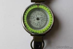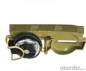


Army or Military Metal Compass DC45
- Ref Price:
-

- Loading Port:
- China Main Port
- Payment Terms:
- TT OR LC
- Min Order Qty:
- -
- Supply Capability:
- -
OKorder Service Pledge
OKorder Financial Service
You Might Also Like


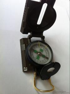
Features:
1)Can easily folds to fit in your pocket
2) The compass is highly accurate and features a liquid-damped compass card with a luminous dial that can easily be read at night, and a standard bezel with two yellow lines at 45 degree angles
3) The compass card has both the standard 0 - 360 degree scale, as well as the 0 - 64Mil scale (one yard at 1,000 yards)
4) The bezel rotates with detents every 3 degrees so you can change the heading reference a known amount without looking at the compass
5) The front sight has a magnifier to simultaneously view the magnetic heading when taking a sight
6) A second magnifier assists in reading the magnetic heading when direct viewing from above
7) When unfolded flat, the marching compass has a straight edge with a standard 1:25,000 or 1:50000 map scale
8) This compass is protected by a durable cast metal case painted dark black with military drab
Specification:
Model: DC45
Name: outdoor hiking or military compass and army compass, metal compass and marching compass in aluminium material
Product Origin: China
Supply Ability: 40,000 pcs/month
Minimum Order: 100 pcs
MOQ for OEM package: 500pcs
Detailed Product Description
Product Size: 74*55.6*27 (mm)
Color: Army Green, Black
Material: Aluminum alloy
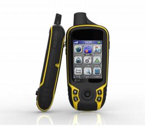
- Q:Interconnection of mobile portable navigator which port Lianxing fast
- HelloNavigation device port, baud rate is fixed.Kelid navigation software, can be found to the stars, and the port settings related to the speed of the search star, and baud rate settings.
- Q:If not, then how to update the map?
- It depends where you bought itIf you want to buy in the 4S shop to buy their own updates should be free of charge
- Q:Portable navigation built-in hard disk or a good memory card
- Of course, the built-in hard disk, the built-in hard disk read faster than the memory card
- Q:Is it good for embedded navigation or portable navigator
- Portable easy to use, cheap, easy to upgrade, but also can be used as a player, put the disadvantages affecting the line of sight on the bench to take down some parking inconvenience (to prevent smashing windows stealing), and wire hanging in there.
- Q:Navigator is portable, the resolution is 480*272, can upgrade to the 2012 Summer Edition map?
- Is planning to buy a navigator, do not know the resolution of the 480*272 navigator, the future will not be eliminated, can not upgrade? Like a computer, like software and hardware upgrades, the final configuration of the computer will be thrown away, the new software can not be installed, depressed, please answer the administrator!
- Q:Portable navigator remove the built-in battery, powered by cigarette lighter, there can not be star search, enter the navigation page after the card or crash, sometimes the screen image is not steady, car is not good, what is going on, how to solve? After a 12V to 36V wide voltage charger or the like
- Navigator wood in the side, open the navigation page directly to the screen, simply can not run the navigation programChasing the answerHello, this should be voltage instability, there may be a problem with the screen.
- Q:How to update the new route GPS portable navigator
- If it is a genuine map, please activate the map on the official website of the vendor and download the official website of the upgrade package after the original map can be covered
- Q:I've upgraded built-in desktop software, electronic dog do not know how to upgrade
- To distinguish between electronic dog software for which the company is currently ninety percent, with good DSA software, if it is good to be good directly to the official website, Download with a new file to replace the old file!
- Q:How to install the navigation map of a portable navigator in a truck to a Android phone
- I used the Tencent map, I feel good ing. Practical。Download the offline map of the Tencent map so you can fully achieve zero traffic navigation, zero flow search. It is not only a common rectangular map and satellite map and street maps and indoor scene, through indoor street also can realize the virtual tourism, it can choose to enjoy the scenic beauty of its street scenery, can enjoy the feast for the eyes. I hope you also apply oh.
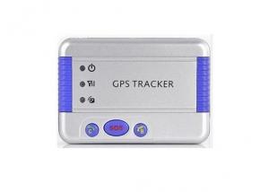
- Q:German born GPS measuring instrument and ziphah handheld measuring instrument Mu Mu which good?
- Ziphah Mu measuring instrument, a key measurement area, the use of simple, SV-118, built-in high precision GPS module import and import antenna, accurate measurement, the error of 0.1 acres, USB charging, high-capacity lithium battery, long standby, manufacturers produced, quality assurance,
1. Manufacturer Overview |
|
|---|---|
| Location | |
| Year Established | |
| Annual Output Value | |
| Main Markets | |
| Company Certifications | |
2. Manufacturer Certificates |
|
|---|---|
| a) Certification Name | |
| Range | |
| Reference | |
| Validity Period | |
3. Manufacturer Capability |
|
|---|---|
| a)Trade Capacity | |
| Nearest Port | |
| Export Percentage | |
| No.of Employees in Trade Department | |
| Language Spoken: | |
| b)Factory Information | |
| Factory Size: | |
| No. of Production Lines | |
| Contract Manufacturing | |
| Product Price Range | |
Send your message to us
Army or Military Metal Compass DC45
- Ref Price:
-
- Loading Port:
- China Main Port
- Payment Terms:
- TT OR LC
- Min Order Qty:
- -
- Supply Capability:
- -
OKorder Service Pledge
OKorder Financial Service
Similar products
New products


Hot products